


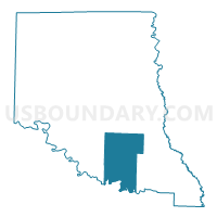
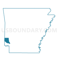
Paraclifta Voting District, Sevier County, Arkansas
About
Outline

Summary
| Unique Area Identifier | 528208 |
| Name | Paraclifta Voting District |
| County | Sevier County |
| State | Arkansas |
| Area (square miles) | 43.35 |
| Land Area (square miles) | 42.54 |
| Water Area (square miles) | 0.81 |
| % of Land Area | 98.12 |
| % of Water Area | 1.88 |
| Latitude of the Internal Point | 33.85611720 |
| Longtitude of the Internal Point | -94.18615160 |
Maps

Graphs
Select a template below for downloading or customizing gragh for Paraclifta Voting District, Sevier County, Arkansas


Neighbors
Neighoring Voting District (by Name) Neighboring Voting District on the Map
- Ben Lomond Voting District, Sevier County, AR
- Burke Voting District, Little River County, AR
- Clear Creek 1 Voting District, Sevier County, AR
- Clear Creek 2 Voting District, Sevier County, AR
- Cleveland Voting District, Little River County, AR
- Lick Creek Voting District, Little River County, AR
- Red Colony South Voting District, Sevier County, AR
Top 10 Neighboring County Subdivision (by Population) Neighboring County Subdivision on the Map
- Clear Creek township, Sevier County, AR (3,460)
- Red Colony township, Sevier County, AR (1,404)
- Cleveland township, Little River County, AR (913)
- Lick Creek township, Little River County, AR (415)
- Paraclifta township, Sevier County, AR (378)
- Burke township, Little River County, AR (297)
- Ben Lomond township, Sevier County, AR (233)
Top 10 Neighboring Unified School District (by Population) Neighboring Unified School District on the Map
- Ashdown School District, AR (9,717)
- Horatio School District, AR (4,045)
- Lockesburg School District, AR (2,220)